With support from CITRIS and the Banatao Institute, Brittany Barreto Martinez demonstrated that satellite imaging can help protect public health by augmenting standard sampling methods.
The San Luis Reservoir in Merced County — one of California’s largest artificial lakes — not only irrigates Central Valley farmland and supplies drinking water across the Silicon Valley and the South Bay, but also draws swimmers, boaters and anglers year-round.
Yet for months at a time, forest-green blankets of algae spread across the lake’s surface. Despite their calm appearance, these harmful algal blooms (HABs) can disrupt water supplies, ecosystems and recreation activities — and pose serious health risks.
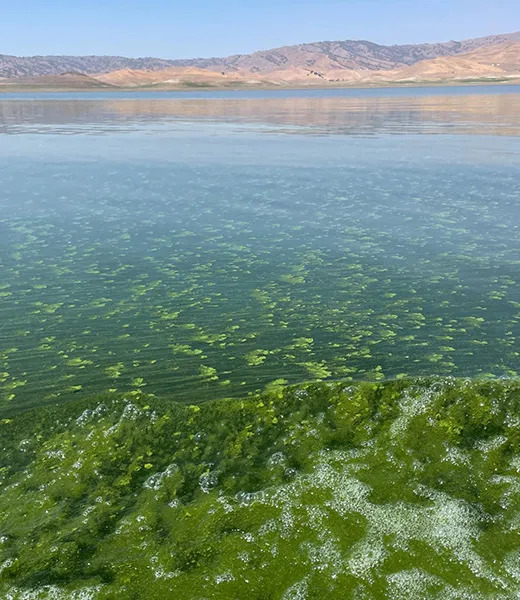
Over the past decade, the California Department of Water Resources (DWR) has issued frequent health advisories for the reservoir. These warnings, which escalate from caution to danger, tell visitors when to avoid the water due to toxins that can cause rashes, eye irritation and flu-like symptoms. HABs have even been implicated in the deaths of several pet dogs in the state in recent years.
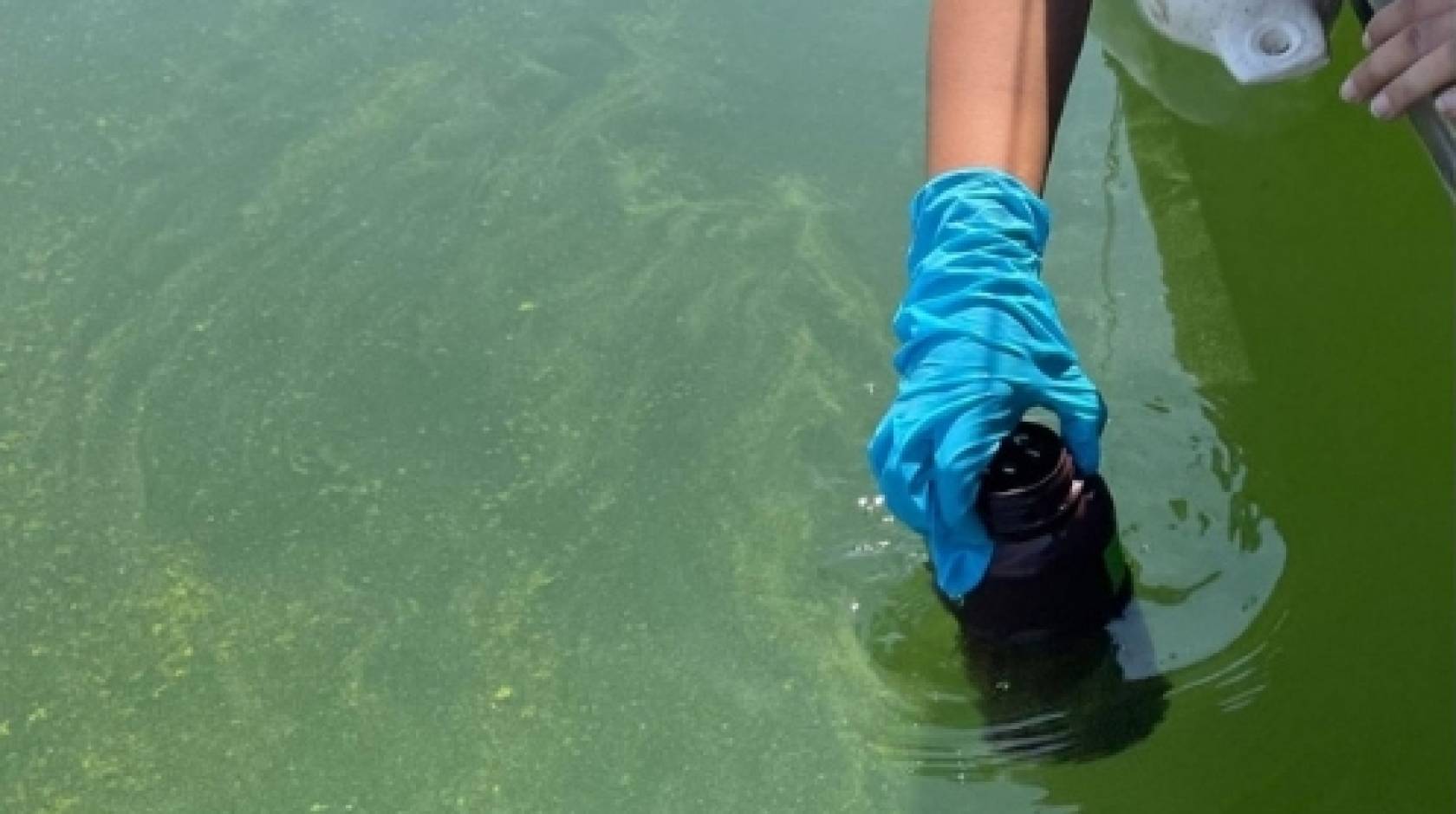
While earning her graduate degree in environmental systems at the University of California, Merced, Brittany Barreto Martinez, now a postdoctoral research fellow at the Disturbance Hydrology Lab at San Diego State University, saw an opportunity to improve HAB monitoring, which has typically relied on shoreline water samples.
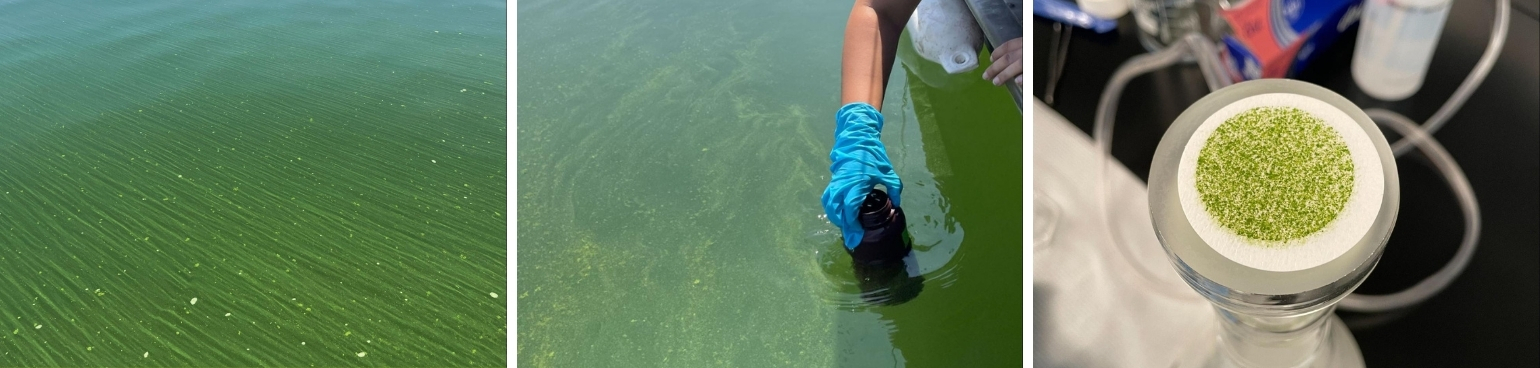
“One day I went out to sample on Labor Day weekend, and naturally people took their boats to fish and swim,” said Barreto Martinez. “At the time, the lake was very green, at a warning level at least. It’s valuable to determine the algal bloom patterns further into the lake rather than just at the lake’s edges, especially if boating and fishing is allowed.”
Tracking blooms from above
Excess algae formation occurs when a water system becomes enriched with nutrients, such as phosphorus and nitrogen. Under such conditions, some algal blooms, including those containing cyanobacteria, dinoflagellates and diatoms, can produce toxins that cause illness when ingested. Cyanobacteria are the most common cause of harmful algal blooms in freshwater systems.
Runoff from fertilizers, sewage and even wildfires can disturb an ecosystem’s balance and lead to an excess of nutrients in lakes and reservoirs. However, the impact of human activities on HAB formation has been hard to define due to the limitations of ground sample collection, which only allows for spot testing, even though algae growth can vary greatly between locations.
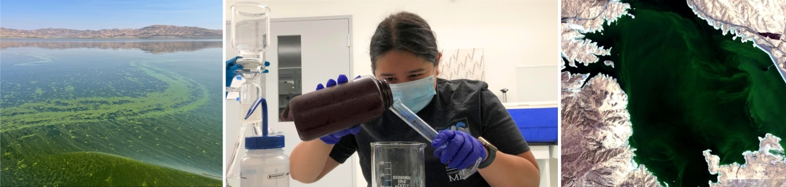
To get a better idea of how algae starts to accumulate away from shore, Barreto Martinez decided to look up — way up. Together with her doctoral advisor, Erin Hestir, a professor of civil and environmental engineering and director of CITRIS at UC Merced, she decided to explore the use of satellite remote sensing to detect HABs within the San Luis Reservoir, across the lake’s full surface.
Barreto Martinez partnered with environmental engineering professor Marc Beutel, who had received funding from CITRIS at UC Merced, to pursue the research. She also received support from the highly selective NASA Future Investigator in Earth Space Science and Technology (FINESST) program, which offers up to three years of funding to promising graduate students pursuing topics of interest to NASA’s Science Mission Directorate.
Seeking the sweet spot in sensor sensitivity
Barreto Martinez and her team started by determining whether existing satellite technologies had the appropriate sensitivity for this new application.
All physical materials possess unique spectral signatures, based on how they absorb and reflect wavelengths of electromagnetic radiation (EMR), especially visible light.
A sensor’s spectral sensitivity, or the range of wavelengths that it measures, and its resolution, or the amount of detail it can detect, both have technological limitations. Unfortunately, given the size and weight constraints inherent to launching a spacecraft into orbit, not every satellite can be equipped to detect every EMR wavelength. Trade-offs on spectral sensitivity and resolution are necessary, and the criteria are carefully considered based on the satellite’s intended purpose.
“We have satellite sensors designed for ocean imaging, and we have satellite sensors designed for land imaging,” said Hestir, “but neither are specifically made to measure the lakes and waterways in the inland part of our nation.”
Land-observing satellites have small pixels that grant higher resolution, but they have low spectral sensitivity to water, which tends to absorb, rather than reflect, the EMR needed to create a useful image. Ocean-observing satellites, on the other hand, are built to detect large bodies of water but their images are composed of accordingly larger pixels.
Bridging the gap in bloom data
Barreto Martinez found two specific satellites, Sentinel 2 and Sentinel 3, that could be used to detect chlorophyll — a reliable proxy for cyanotoxins, according to the World Health Organization — and both chlorophyll and cyanobacteria, respectively.
Thanks to its wider spectral sensitivity, Sentinel 3 was able to confirm when cyanobacteria and chlorophyll were both present, while the higher-resolution Sentinel 2 could discern variability in the density of the algal bloom across different areas of the lake.
For her investigation, Barreto Martinez used open-source information from Sentinel 2 and Sentinel 3 taken between 2016 and 2022, selecting images that were taken on the same days that the DWR collected water samples from the dock.
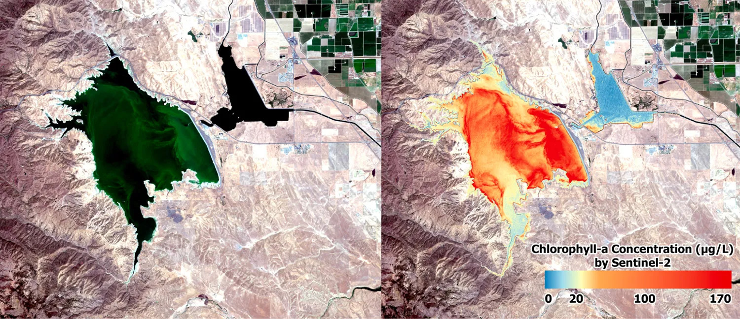
As the team shared in the journal GeoHealth, the resulting data from Sentinel 2 showed more than 79 percent agreement with the toxin levels found in the ground samples, and Sentinel 3 found 83 percent agreement. In other words, the information from the satellites corresponded to a high degree with the dockside HAB toxin detection, demonstrating the ability of remote sensing to determine the size and location of algal blooms within the lake.
Barreto Martinez’s work made strides toward closing a striking data collection gap and promoting a greater degree of public safety. Moving forward, data from satellite sensing can help the DWR decide where to take ground samples, while allowing the agency to issue more accurate public health alerts even more quickly.
Hestir attributed the project’s impact to Barreto Martinez’s methodical approach.
“Brittany was very persistent,” she said. “She took it upon herself to become an expert in the relevant satellite technology, develop sophisticated coding and data analysis skills, build deep system knowledge of these lake ecosystems, and even obtain certification to launch and drive a boat to collect verification samples.”
Identifying an alarming trend
When the team reviewed historical data from all California lakes visible from space, they found a surprising increase in the number of toxic HAB alert days statewide — especially in Southern California — over the past 15 years.
This trend parallels a rise in severe wildfires over the last two decades, raising a new question: Could wildfires be driving the increase in lake algae, directly or indirectly?
Hestir’s NASA-funded KelpFire project, which examines wildfire runoff’s effects on coastal kelp, has shown that vegetation loss increases sediment and surface runoff. After a fire, this can alter nutrient levels entering lakes and reservoirs.
“How much of the watershed was burned? And what burned?” said Hestir. “Were human settlements destroyed that might be adding harmful pollutants and heavy metals into the waterways?
“We are working hard with our colleagues at NASA, UCLA and USGS to better understand when and why a wildfire has an impact.”
Hestir’s research is among several emerging collaborations between CITRIS researchers and NASA, fostered by the CITRIS Aviation initiative.
Keeping humans in the loop
In the meantime, on-site sampling will remain essential at the San Luis Reservoir for monitoring qualities of the water that cannot be determined visually, such as nutrient levels.
“Remote sensing is not intended to replace ‘grab’ samples; the two techniques work hand in hand,” said Barreto Martinez. “Where humans can’t, these machines can.”
By introducing a supplementary measuring tool that uses accessible and reliable data, Barreto Martinez was able to extend the capabilities of remote sensing further than she had once thought possible.
“Addressing the public health perspective was very rewarding,” she said, “because it connected the sensing technology to improving people’s day-to-day lives and safety.”
Photos courtesy of Brittany Barreto Martinez